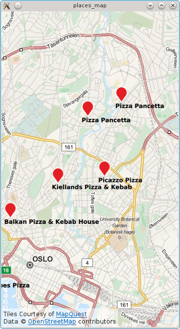
The example displays a map of the current location or, if no position is available, it uses Brisbane/Australia. Subsequently a search for places matching the term "pizza" is performed and each result shown on the map.
要运行范例从 Qt Creator ,打开 欢迎 模式,然后选择范例从 范例 。更多信息,拜访 构建和运行范例 .
To write the QML application that will show places on a map, we start by making the following import declarations.
import QtQuick 2.0
import QtPositioning 5.5
import QtLocation 5.6
Instantiate a Plugin instance. The Plugin is effectively the backend from where places are sourced from. Depending on the chosen plugin some manadatory parameters may be needed. In this case the OSM plugin is selected which does not have any mandatory parameters.
Plugin {
    id: myPlugin
    name: "osm" // "mapboxgl", "esri", ...
    //specify plugin parameters if necessary
    //PluginParameter {...}
    //PluginParameter {...}
    //...
}
Next we instantiate a PlaceSearchModel which we can use to specify search parameters and perform a places search operation. For illustrative purposes, update() is invoked once construction of the model is complete. Typically update() would be invoked in response to a user action such as a button click.
property variant locationOslo: QtPositioning.coordinate( 59.93, 10.76)
PlaceSearchModel {
    id: searchModel
    plugin: myPlugin
    searchTerm: "Pizza"
    searchArea: QtPositioning.circle(locationOslo)
    Component.onCompleted: update()
}
The map is displayed by using the
地图
type and inside we declare the
MapItemView
and supply the search model and a delegate. An inline delegate has been used and we have assumed that every search result is of
type
PlaceSerachesult
. Consequently it is assumed that we always have access to the
place
role
, other search result types may not have a
place
role
.
Map {
    id: map
    anchors.fill: parent
    plugin: myPlugin;
    center: locationOslo
    zoomLevel: 13
    MapItemView {
        model: searchModel
        delegate: MapQuickItem {
            coordinate: place.location.coordinate
            anchorPoint.x: image.width * 0.5
            anchorPoint.y: image.height
            sourceItem: Column {
                Image { id: image; source: "marker.png" }
                Text { text: title; font.bold: true }
            }
        }
    }
}
Finally, a
PositionSource
is used to reset the map to the curent location and find "pizza" places in the new area. The position information is updated every 2 minutes and if the new position is more than 500 meters away from the last pizza search area the place search is retriggered.
PositionSource {
    id: positionSource
    property variant lastSearchPosition: locationOslo
    active: true
    updateInterval: 120000 // 2 mins
    onPositionChanged:  {
        var currentPosition = positionSource.position.coordinate
        map.center = currentPosition
        var distance = currentPosition.distanceTo(lastSearchPosition)
        if (distance > 500) {
            // 500m from last performed pizza search
            lastSearchPosition = currentPosition
            searchModel.searchArea = QtPositioning.circle(currentPosition)
            searchModel.update()
        }
    }
}
文件: